
Everything between a DXF file and a finished lot register
ForgeLot takes your design alignment, gives it chainage, lets you forge lots along it, and keeps a live, exportable record of what's been built.
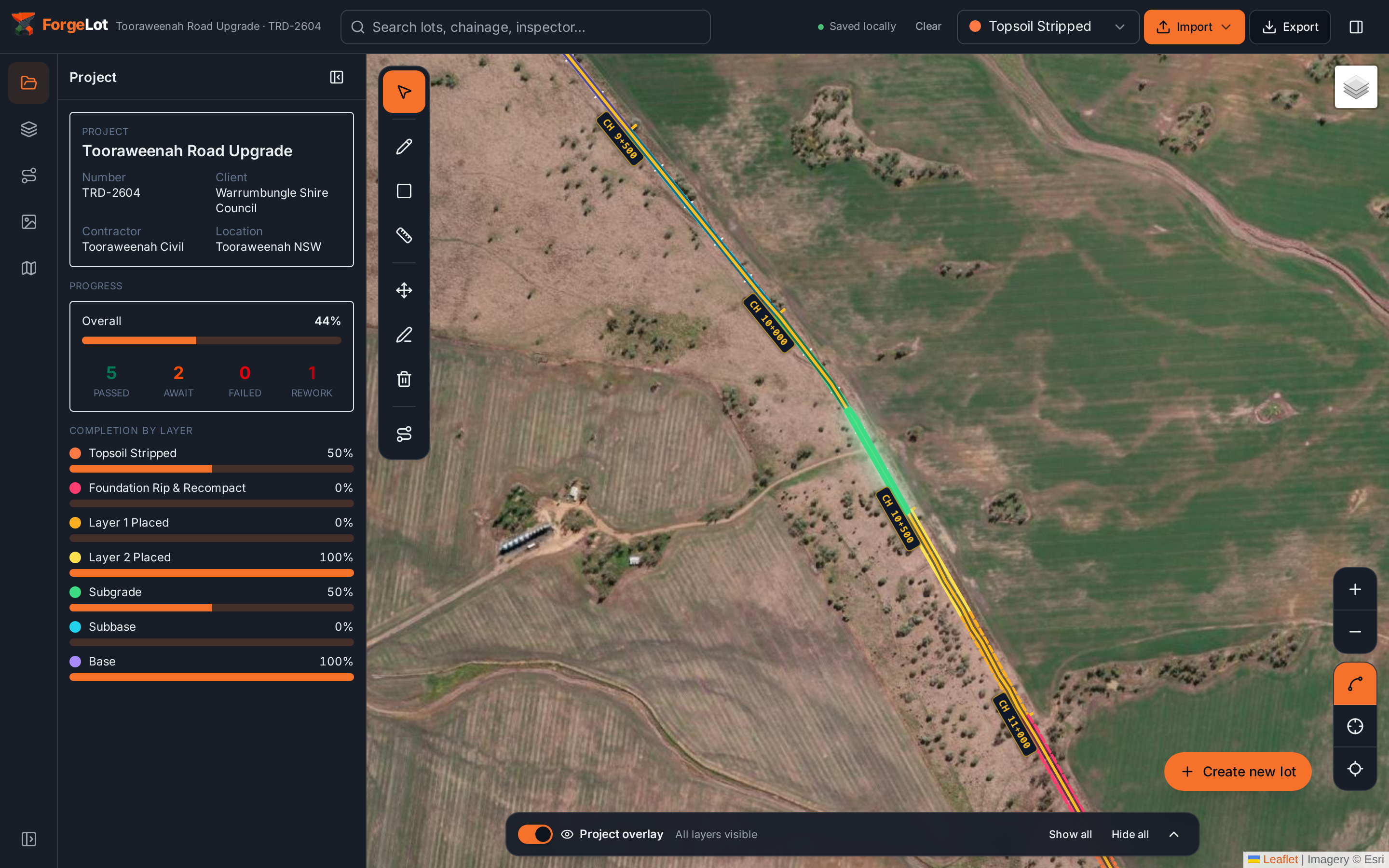
Actual product view
The whole corridor in one live picture
See completion by layer, failed and rework lots, chainage and project totals without leaving the map.
ForgeLot as construction quality management softwareDXF & alignment import
Bring in your design file as-is and let ForgeLot do the interpreting.
- Drag-and-drop DXF upload, no conversion step
- Auto-detects candidate coordinate reference systems
- Recognises polylines suitable for use as an alignment
- Keeps the original geometry untouched, nothing is redrawn by hand
Chainage & control line
Lock a single control line and let chainage markers generate themselves.
- Pick and lock the alignment that everything else measures against
- Set a start chainage and interval, markers place automatically
- Adjust or relabel markers without re-importing the DXF
- Chainage stays consistent for every lot created afterwards
Corridor lot creation
Describe a lot the way you already think about it: chainage range and offsets.
- Enter a from/to chainage and left/right offset distance
- ForgeLot forges the corridor shape on the satellite basemap for you
- Area is computed automatically, no manual measuring
- Split, merge or adjust lots as scope changes on site
Layer & status tracking
Every lot carries a construction layer and a status your whole team recognises.
- Layers from Topsoil Stripped through to Base
- Statuses covering Planned through to Complete or Rework Required
- Bulk update lots as a shift or activity finishes
- Full history of who changed what, and when
Visual progress map
See the whole corridor coloured by status or layer, at a glance.
- Satellite basemap with fast rendering even at high zoom
- Colour lots by status or by construction layer
- Filter the map by chainage range, layer or status
- Click any lot for its full detail without leaving the map
Reporting & exports
Turn the register into something you can hand to a client or an auditor.
- Export the full lot register to CSV for further analysis
- Generate PDF registers for meetings and handover packs
- Filter exports by status, layer or chainage before you send them
- Numbers match the map, there is only one source of truth
Made to run on the tailgate of a ute, not just at a desk
ForgeLot is a workspace engineers actually open on site, on a tablet, in patchy signal, without waiting for the map to catch up.
Mobile & tablet ready
The workspace adapts to phone and tablet screens so it works from the cab or the site office.
Offline-tolerant workspace
Patchy site connectivity doesn't stop you reviewing lots and picking up where you left off.
Fast at high zoom
Zoom right into a single lot on the satellite basemap without the map lagging behind you.
A lot of small features add up
Beyond the core workflow, ForgeLot is full of the small conveniences that save an engineer real time.
Automatic area calculation
Every lot's area is computed the moment its geometry is set.
Click-to-inspect lots
Tap any lot on the map to see its full history and detail.
Edit history
Every status and layer change is kept, so nothing gets lost in a shift handover.
Team workspaces
Invite engineers, surveyors and QA staff into the same live project.
Role-aware access
Control who can edit lots versus who can only view the register.
Chainage relabelling
Rename or renumber markers without disturbing existing lots.
Fast lot search
Find a lot by chainage, layer or status in seconds.
Custom colour schemes
Set the palette your team already uses for status or layer.
Bulk export filters
Export exactly the slice of the register a client has asked for.
Standard civil layer set
Track the usual construction sequence from topsoil strip to base. Custom layer sets are on the roadmap.
Multi-alignment projects
Manage several alignments, mainline and side roads, in one project.
Status change guardrails
Keep status progression sensible without slowing anyone down.
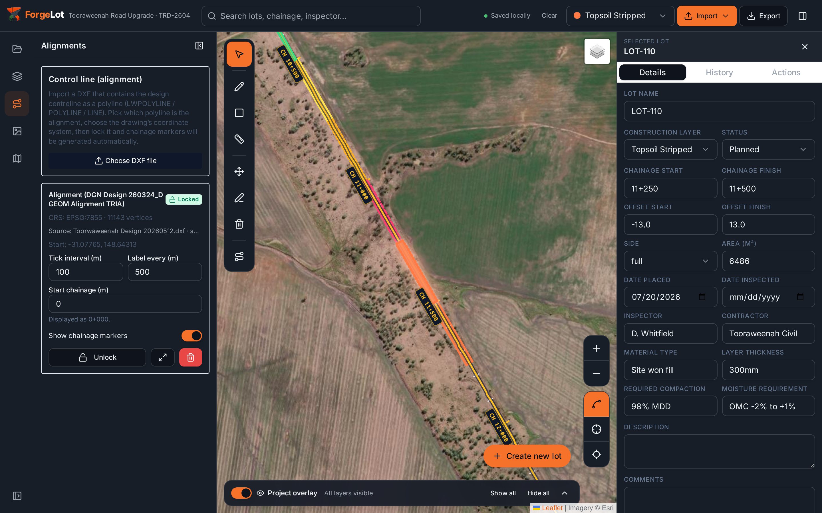
Works with the projections Australian and New Zealand projects actually use
ForgeLot auto-detects the likely coordinate reference system from your DXF and lets you confirm or override it before any chainage is generated.
- GDA2020 MGA Zone 54
- GDA2020 MGA Zone 55
- GDA2020 MGA Zone 56
- GDA94 MGA
- NZTM2000
- Web Mercator
- Custom proj4 definitions
Stop guessing what's been built.
Import your alignment, forge your lots and share a live picture of progress with the whole team.
14-day free trial · Cancel anytime · Your data stays yours